API Documentation
Getting Started
This document provides a brief introduction to using the IIPMaps API.
The base URL for the API is https://iipmaps-api.vercel.app.
Map Generation
To generate a map, you need to send a POST request to {{baseurl}}/api/generate-map with the following data structure:
{
  "mapName": "india",
  "size": 1200,
  "data": {
    "Andhra Pradesh": 6084.7,
    "Arunachal Pradesh": 17.41,
    "Assam": 4196.92,
    "Bihar": 17575.4,
    "Chhattisgarh": 6854.34,
    "Gujarat": 13980.29,
    "Haryana": 5883.87,
    "Himachal Pradesh": 1875.24,
    "Jammu & Kashmir": 1339.12,
    "Jharkhand": 3734.08,
    "Karnataka": 7517.63,
    "Kerala": 2802.44,
    "Madhya Pradesh": 21247.25,
    "Maharashtra": 13882.96,
    "Manipur": 339.87,
    "Meghalaya": 517.76,
    "Mizoram": 191.45,
    "Nagaland": 456.24,
    "Odisha": 9510.49,
    "Punjab": 5856.37,
    "Rajasthan": 2119.66,
    "Sikkim": 138.2,
    "Tamilnadu": 9182.78,
    "Telangana": 1943.53,
    "Tripura": 847.72,
    "Uttar Pradesh": 29160.88,
    "Uttarakhand": 1030.34,
    "West Bengal": 28432.28
  }
}
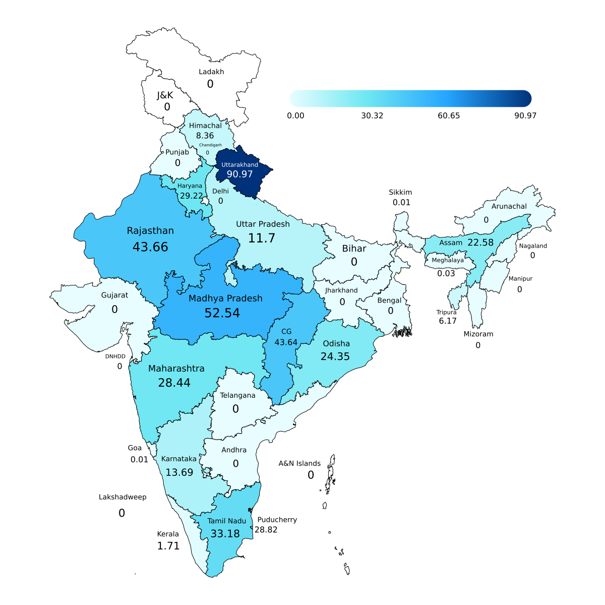
This would return a base 64 encoded image of the map. Like this:
{
  "result": "data:image/png;base64,iVBORw0KGgoAAAANSUhEUgAABLAAAASwCAIAAABkQySYAAAACXBIWXMAAAsTAAALEwEAmpwYAAAgAElEQVR4nOzdB1RTdxsG8IvK3htlqKCotShV68BRF+4Jbq0iilotahU3DtyzzqK4iwPrxokiKsuBqEwZgggCskcSsm/udyB+acRRB+Em5Pmd5/TUSxJe..."
}
You can then use this image in your application. For example, you can display it in an <img> tag like this:
<img src="{resp.result}" alt="Map" />
This would display the map like this:
mapNameshould be one of the valid map names listed below:
Click to see the list of valid mapNames
- andhranew
- africa
- andhrapradesh
- arunachalpradesh
- asia
- assam
- bangladesh
- bangladesh_dist_m
- bengalx
- bharat
- bhutan
- bihar
- chhattisgarh
- china
- constituencies_m
- delhi
- europe
- goa
- gujarat
- haryana
- himachalpradesh
- india
- indiadist_m
- jammukashmir
- jharkhand
- karnataka
- kerala
- madhyapradesh
- maharashtra
- manipur
- meghalaya
- mizoram
- nagaland
- nepal
- nepal_dist_m
- nepal_old
- north-america
- oceania
- odisha
- pakistan
- punjab
- rajasthan
- sikkim
- south-america
- south-asia
- sri_lanka
- tamilnadu
- telangana
- tripura
- usa
- uttarakhand
- uttarpradesh
- westbengal
- westeros
- world
- worldflat
Map customization
size| number (optional): Size of the map. If not specified, the default size is 1200.lang| string (optional): The language in which to display region names. If not specified, the default language is English.focus| string[] (optional): An array of regions to focus on. This field is only applicable for maps with names ending in_m. For example, if you want to focus on the states of Maharashtra and Gujarat in the indiadist_m map, you can specify thefocusfield like this:
{
  "focus": ["Maharashtra", "Gujarat"]
}
palette| string or object (optional): The color palette to use for the map. If not specified, the default palette isLadakh. The following palettes are supported:
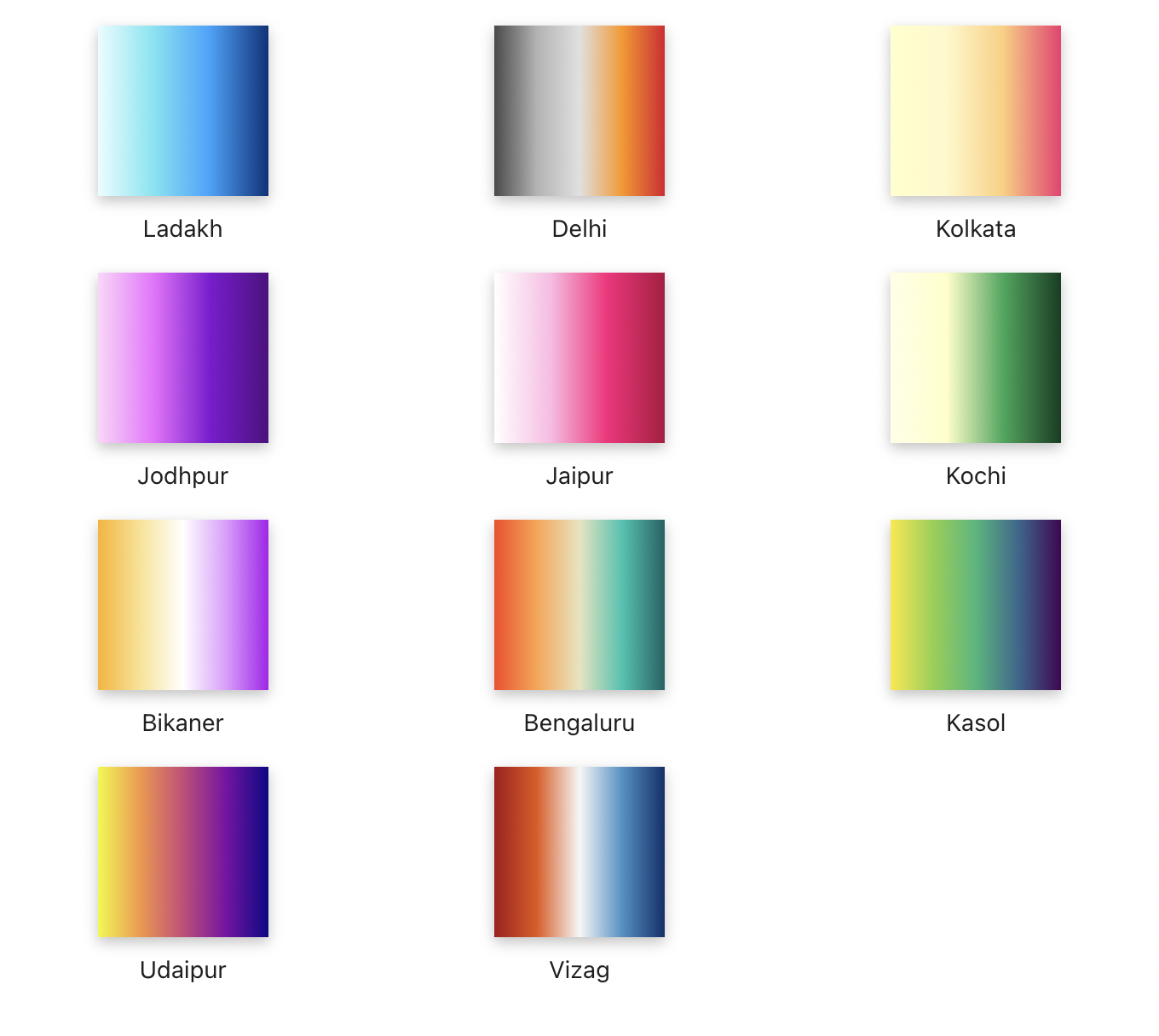
You can also specify your own custom palette. For example, this is the palette used for Ladakh:
[
  {
    "pos": 0,
    "color": "#e8fdff"
  },
  {
    "pos": 0.315,
    "color": "#6fe7f2"
  },
  {
    "pos": 0.652,
    "color": "#24a5ff"
  },
  {
    "pos": 1,
    "color": "#00327b"
  }
]
bgcolor| string (optional): The background color of the map. It can either be hex or rgb. If not specified, the default background color is#ffffff.
Metadata
IIPMaps API supports a wide range of regions and languages. You can retrieve the full list of supported regions and languages by making a GET request to {{baseurl}}/api/metadata?mapName=india.
The response looks like this:
{
  "regions": [
    {
      "name": "Madhya Pradesh"
    },
    {
      "name": "Delhi"
    },
    {
      "name": "Uttarakhand"
    },
    {
      "name": "Himachal Pradesh"
    },
    {
      "name": "Ladakh"
    },
    {
      "name": "Jammu and Kashmir"
    },
    {
      "name": "DNHDD"
    },
    {
      "name": "Chandigarh"
    },
    {
      "name": "Puducherry"
    },
    {
      "name": "Tamil Nadu"
    },
    {
      "name": "Andaman and Nicobar Islands"
    },
    {
      "name": "Mizoram"
    },
    {
      "name": "Manipur"
    },
    {
      "name": "Nagaland"
    },
    {
      "name": "Arunachal Pradesh"
    },
    {
      "name": "Sikkim"
    },
    {
      "name": "Bihar"
    },
    {
      "name": "Uttar Pradesh"
    },
    {
      "name": "Haryana"
    },
    {
      "name": "Andhra Pradesh"
    },
    {
      "name": "Karnataka"
    },
    {
      "name": "Goa"
    },
    {
      "name": "West Bengal"
    },
    {
      "name": "Jharkhand"
    },
    {
      "name": "Chhattisgarh"
    },
    {
      "name": "Kerala"
    },
    {
      "name": "Tripura"
    },
    {
      "name": "Meghalaya"
    },
    {
      "name": "Assam"
    },
    {
      "name": "Punjab"
    },
    {
      "name": "Gujarat"
    },
    {
      "name": "Maharashtra"
    },
    {
      "name": "Odisha"
    },
    {
      "name": "Rajasthan"
    },
    {
      "name": "Telangana"
    },
    {
      "name": "Lakshadweep"
    }
  ],
  "langs": [
    "English",
    "Hindi",
    "Odia",
    "Kannada",
    "Malayalam",
    "Tamil",
    "Bengali",
    "Punjabi",
    "Gujarati",
    "Telugu",
    "Urdu",
    "Axomiya"
  ]
}
The regions array in the response contains all the regions that can be displayed on the map, while the langs array contains all the supported languages.